The output value of the geographic information industry has grown by more than 20% for more than 10 consecutive years –
Smart maps for future navigation
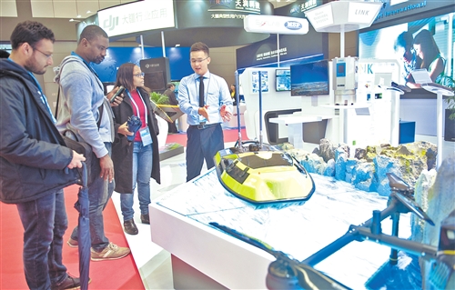
On November 18, the first United Nations World Geographic Information Conference Technology and Application Exhibition opened in Deqing County, Zhejiang Province. The picture shows exhibitors introducing an intelligent unmanned surveying ship to visitors. Xinhua News Agency reporter Photo by Weng Xinyang
Since the beginning of the 21st century, geospatial information technology has been deeply integrated with the Internet, big data, cloud computing, artificial intelligence, etc., giving birth to new products, new services, new business models, and more deeply affecting economic and social development and the daily lives of ordinary people. Geospatial information will become the infrastructure of the digital economy era like "water" and "electricity", "navigating" for the future
Now, even in an unfamiliar place, people don’t have to worry about getting lost. They can easily find the place they want to go by taking out their mobile phone to locate and navigate. Even, what food and shopping places are around, you can easily find out through your mobile phone.
Today, the professional and mysterious geographical information in the eyes of people in the past is so closely related to real life. From November 19 to 21, the first "United Nations World Geographic Information Conference" with the theme of "Drawing Space Blueprints Together to Build a Better World" was held in Deqing, Zhejiang. Here, not only did geographic information experts and scholars imagine the future, but also various companies exhibited the latest geographical information application results.
Become the infrastructure of the future
Do you understand? Eighty percent of information about human activities is related to geography. Liu Zhenmin, the deputy secretary-general of the United Nations, said that geographic information, like "water" and "electricity," is an infrastructure that will be ubiquitous.
In general, geographic information technology includes geographic information system, remote sensing, Global Positioning System and digital earth technology, and is widely used in economic construction, social development, ecological protection and disaster early warning.
Since the beginning of the 21st century, the deep integration of geographic information technology with the Internet, big data, cloud computing, artificial intelligence, etc., has given birth to new products, new services, and new business models, and has profoundly affected economic and social development and the daily lives of ordinary people.
Data show that the output value of our country’s geographic information industry has increased by more than 20% for more than 10 consecutive years. As of the end of June 2018, the number of employees in our country’s geographic information industry exceeded 95,000. The total output value of the geographic information industry in 2018 is expected to exceed 620 billion yuan, an increase of 20% year-on-year.
Alibaba CEO Zhang Yong said that in the 19 years since its establishment, Alibaba has grown from a small company to a huge digital economy covering e-commerce, payment, cloud computing, logistics and other fields, which cannot be separated from the support of geographic information technology.
He believes that geographic information technology is the bedrock of the digital economy and will become the infrastructure of the future digital economy.
It is based on this realization that Alibaba acquired Autonavi Maps in 2014. Currently, Autonavi Maps provides real-time traffic conditions in more than 360 cities and all highways across the country, with minute-level updates.
"We provide geographic information services not only for consumers, but also for third parties, and its extended functions such as logistics, food and beverage delivery, driverless driving, and autonomous driving are forming an ecosystem," Mr. Zhang said.
Experts say that geographic information is an important prerequisite for accurately grasping national conditions and strength, a country’s basic and strategic resources, and an important basis for governments to implement development plans, carry out macro-management, maintain national security, and build ecological civilization. It must be fully utilized and made good use of.
Empowering new industries and new business models
At the first United Nations World Geographic Information Congress Technology and Applications Exhibition, more than 200 participating companies showcased their new applications of geographic information technology.
In the southern surveying booth, fixed-wing, multi-rotor and other drones were arranged in sequence; millimeter-level precision surveying and mapping instruments attracted many professionals to stop and visit.
According to Guo Qing, a surveying and mapping staff member in the south, drones can be applied to agricultural insect control, forest fire prevention and many other scenarios to achieve efficient and automated data collection. These jobs that previously required a lot of high-intensity field operations can now be easily completed through drones.
He said that Southern Surveying and Mapping has now created a new model of surveying and mapping engineering in drone aerial surveying, 3D laser scanning measurement, indoor positioning and navigation systems, and developed new business models.
In recent years, gas pipeline leakage and explosion, urban waterlogging, road collapse and other situations have occurred from time to time. How to ensure the safety of the urban underground pipeline network that is beyond people’s sight?
At the Zhengyuan Information booth, staff member Wang Lei introduced that the problem of urban pipeline network safety will be solved in four steps. First, carry out a census of urban underground drainage, gas, heat and other pipelines; second, carry out hidden danger investigation of underground pipelines and surrounding environment to form a pipeline health file database; third, strengthen governance for related problems; fourth, install Internet of Things sensing devices for key locations and equipment of pipelines to realize real-time monitoring of the safe operation status of underground pipelines, so as to improve the safety supervision level of pipelines.
At the JD.com booth, the unmanned delivery vehicle attracted the attention of many attendees. With the support of high-precision maps, this unmanned delivery vehicle can accurately park at the delivery point through autonomous positioning and navigation, and realize point-to-point logistics distribution. According to reports, JD.com unmanned vehicles are currently in operation in Beijing, Shanghai, Tianjin, Guangzhou and other places.
Smart agriculture, smart tourism, smart transportation, smart medical care – geographic information technology is constantly giving birth to new industries and new business models, making cities smarter and people in cities enjoy a more convenient life.
Smart maps are becoming the product of machine learning and the best representation of artificial intelligence, Zhang says. A truly intelligent map knows what you want and can make judgments for you based on your previous behavior.
Derivatives are everywhere.
What can geographic information technology do for cultural heritage protection? At the booth of Guangzhou Ouke Information Technology joint stock company, 360-degree panoramas, three-dimensional models and other forms showed our country’s rich cultural heritage data results, as well as the dynamic protection system of cultural heritage "point-line-surface".
Xiong Aiwu, chairperson of the Guangzhou-based Euco Information Technology joint stock company, said that in the past there were many urban plans, but they were often "separate", and it was inevitable that there would be collisions between plans. By collecting relevant geographical information and integrating cultural heritage data into urban planning, cultural heritage protection was achieved at the planning stage.
In this booth, there is also an interactive experience area, where cultural heritage is disseminated through various forms such as scanning the code to see the building, enhancing the public’s experience.
Through AI (artificial intelligence) technology, land violations and chaos can also be detected early. In the exhibition, the reporter saw that the Land and Resources Bureau of Zibo City, Shandong Province cooperated with Alibaba to realize the automatic analysis, identification and comparison of satellite remote sensing images for the first time in the country using artificial intelligence technology. This move has greatly improved the efficiency of land and resources supervision and law enforcement, shortening the analysis and comparison of remote sensing photos that originally took several months to complete to a few minutes. In this way, the previous punishment for land violations can be turned into intervention in the event.
At the conference, many experts and scholars also mentioned that while the current development of geographic information technology allows people to enjoy convenience, the greatest concern is the security of personal information, including information leakage and the unreasonable use of information.
In addition, the issue of the "digital divide" caused by the level of regional development also attracted the attention of the participating experts. Due to uneven development, it may lead to a widening gap in the application of digital information technology in various regions, eventually creating a vicious circle.
"Let’s use geospatial information to build a safer, better world where no one is left behind." The congratulatory video sent by UN Secretary-General António Guterres to the conference resonated with many attendees, and this may be the direction of future efforts. (Reporter, Huang Xiaofang)
